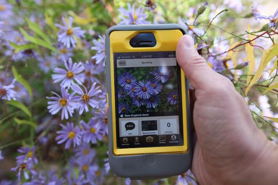
With iPhones in hand, visitors to national wildlife refuges
in the Chesapeake Bay region can now photograph and share their sightings with
a worldwide community of wildlife watchers.
The free National Wildlife Refuges Chesapeake Bay app is a new tool for exploring the
outdoors and is available for download from the App Store (http://bit.ly/QTS53B).
The app comes online just as the nation celebrates National
Wildlife Refuge Week, October 14-20, when the Chesapeake Bay-region refuges are
holding wildlife walks and other events that are perfect opportunities for
people to use the app.
App users can post photos of the plants and animals they
find on refuges and tap into a global network of experts for information about
the species. As the postings
accumulate, scientists and refuge managers will be able to view the data to see
where and when species inhabit specific locations.
The app was developed through a partnership between the Chesapeake Conservancy and National Geographic Society with
support from the U.S. Fish and Wildlife Service.
It incorporates the popular Project Noah
wildlife photo-sharing service.
Project Noah allows users to create “missions” to pursue,
and the app includes a mission for 11 national wildlife refuges in the
Chesapeake Bay region, the largest estuary in the U.S. The app also includes location,
maps, operating hours and guides for these refuges. Users who visit the refuges and post photos can
earn virtual “patches.” There is one patch for each refuge.
Joel Dunn, Executive Director of the Chesapeake Conservancy,
which developed the idea and gained financial support to build it through a
partnership with National Geographic and Project Noah, said, “Our goal was to
produce a fun and innovative app that allows people to explore the Chesapeake
region’s National Wildlife Refuges, so everyone can better understand and
appreciate the extraordinary value of these protected areas and our wildlife in
the Bay and along our great rivers.”
“The app provides a new interactive experience by
encouraging refuge visitors to become modern explorers. By using their
smartphones like digital butterfly nets to capture photos of the animals and
plants they discover, they chronicle and share their experiences at the
refuges, adding their photos to a growing global database used by citizen
scientists across the globe,” said Charles Regan, Senior Vice President for
National Geographic Maps.
“The Chesapeake refuge
app is a free resource for everyone seeking to learn about the Chesapeake Bay and its national wildlife refuges, but
it’s more than a great educational tool. It also allows wildlife enthusiasts to
share photos and information with biologists and experts from the Fish and
Wildlife Service and across the globe, enabling citizen scientists to help us
learn more about the kinds and distribution of plants and animals that inhabit
refuges in one of the nation’s most imperiled watersheds,” said U.S. Fish
and Wildlife Service Director Dan Ashe. “I can’t think of a better way to
get a whole new generation fired up about wildlife than putting this app in a
million hands.”
Established in 1903,
the National Wildlife Refuge System, managed by the U.S. Fish and Wildlife
Service, spans 560 refuges and 38
Wetland Management Districts across 150 million acres. There is a wildlife refuge in every state and
U.S.
territory. For more information about
the Refuge System, go to: http://www.fws.gov/refuges/
The Chesapeake
Conservancy’s mission is to strengthen the connection between people and the
watershed, conserve the landscapes and special places that sustain the Chesapeake’s unique natural and cultural resources, and
encourage the exploration and celebration of the Chesapeake as a national treasure.
www.chesapeakeconservancy.org
This press release is presented without editing for
your information. GRIT does not recommend, approve or endorse the products
and/or services offered. You should use your own judgment and evaluate products
and services carefully before deciding to purchase.