
Occasionally, you’ll hear a meteorologist refer to the jet stream or even display a map showing its location. So, what is the jet stream, and why is it important for our weather?
The jet stream is a fast-flowing “river” of air that encircles the Earth and lies well above the Earth’s surface, with its core typically near 30,000 feet. Wind speeds often exceed 100 mph and can reach 200 mph or more. Meteorologists officially call this jet stream the “polar jet.”
What Causes Jet Streams?
The driving force of the jet stream – and, in fact, all winds – is temperature contrast. The strongest winds occur where relatively cold air meets relatively warm air. This area of temperature contrast, along with the polar jet, moves seasonally. In summer, it’s near the U.S. and Canada border and it tends to be weakest. With the colder temperatures of fall and winter, the polar jet moves southward well into the U.S., reaching its maximum strength. Besides temperature contrast, the Earth’s rotation also impacts the jet stream. In the Northern Hemisphere, this causes the polar jet to flow overall from west to east, a westerly wind. The Southern Hemisphere has its own polar jet stream that also blows from west to east.
The jet stream is envisioned as a line of strong winds that circles the planet. In reality, the wind speed varies greatly along this line, or “jet axis.” In some places, it’s fairly weak, but it still has stronger winds than the area surrounding it. In other places, it’s much stronger, and these are called “jet streaks.”
In which direction do jet streams generally travel? In which direction do jet streams generally travel? Although the jet stream flows from west to east, it typically has waves. Dips in the jet stream are called “troughs” and are comprised of colder air. Rises, called “ridges,” contain warmer air. The core of the jet stream is embedded within these ridges and troughs. These ridges and troughs also move, but, like jet streaks, at much slower speeds than the jet stream they encompass, typically 20 to 40 mph slower.
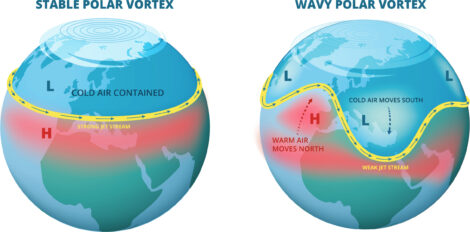
So, how does the jet stream way up in the atmosphere affect weather here at the surface? Actually, it’s a major factor in the weather we live with. First, it acts as a path for surface high- and low-pressure areas to follow. When the jet stream dips southward in a trough, cold air at the surface will follow it. This cold air sinks and spreads out as it moves well south of the upper-level jet stream. When the jet surges northward with a ridge, warm air will dominate the weather. As for clouds and precipitation, ridges tend to be associated with dry weather, but troughs, especially on their eastern sides, often bring low pressure, clouds, and precipitation. Extremely dynamic troughs can initiate major storms at the surface, even the rapidly developing “bomb cyclones.”
In late summer and fall, tropical systems, such as hurricanes, develop well south of the polar jet stream. However, when they move poleward, they, too, are steered by the upper-level winds. Typically, these stronger winds aloft will weaken the storm. An upper-level trough can sometimes transform a tropical cyclone into a strong, but more typical, winter-like storm.
At times, the atmosphere can get into a pattern in which ridges or troughs recur at similar locations over longer periods. This is when the surface weather can persist for weeks or even months. Wet spells or even recurrent flooding can occur in some areas, while other locations endure drought. When the jet stream flattens out, it’s called a “zonal flow,” during which weather systems tend to be weaker and move faster.
There are other jet streams in the atmosphere. The subtropical jet stream is primarily important in winter. It can be located along the southern part of the United States (specifically, near 30 degrees latitude), and tends to be stronger and impact weather more during El Niño winters. The subtropical jet stream can help fuel a southern storm track, bringing heavier precipitation. Occasionally, an arctic jet stream can be seen north of the main polar jet stream. And jet streams can merge: the polar with the subtropical, the arctic with the polar.
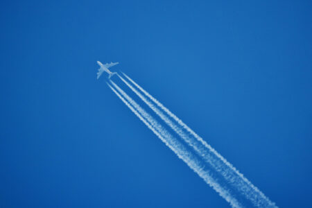
Because the core of the strongest jet stream winds is usually 30,000 to 35,000 feet above the surface, this often coincides with the flight altitudes of larger jet aircraft. To minimize flight time, the flight paths of these planes are designed with the jet stream in mind. Going against the jet stream means longer flights and more fuel usage, so pilots try to avoid it.
However, one concern with jet streams is turbulence. When wind speed changes significantly over short distances, as it does near the jet stream core, vertical eddies can form. If a plane flies through these eddies, it can drop suddenly. This is called turbulence. And, unlike turbulence you find in thunderstorms, this occurs away from any clouds and is called “clear air turbulence” (CAT). It’s impossible to see and difficult to forecast. Although not always associated with the jet stream, unforeseen CAT events account for the majority of injuries reported by airlines. Airplanes are designed to withstand this turbulence. Staying seated with your seat belt on will prevent almost all injuries.
An interesting historical note: The jet stream played a role in World War II. The Japanese military used the jet stream by sending balloon-borne bombs eastward across the Pacific Ocean, using the strong westerly winds at high altitude. Most of the bombs failed to reach the West Coast, but a few did, causing some casualties and damage (kept secret here at the time to prevent panic). On the other side of the ocean, high-altitude American bombers remained motionless over targets in Japan when their forward airspeed was counteracted by headwinds in excess of 200 mph.
For more than 30 years, Ed Brotak taught college students about weather, and he’s helped many pursue careers in meteorology. He lives in Asheville, North Carolina, with his wife, Liz.
Originally published in the January/February 2026 issue of Grit magazine and regularly vetted for accuracy.


